
Three Bears, Watchman, & Five Mile Gulch Trails Loop


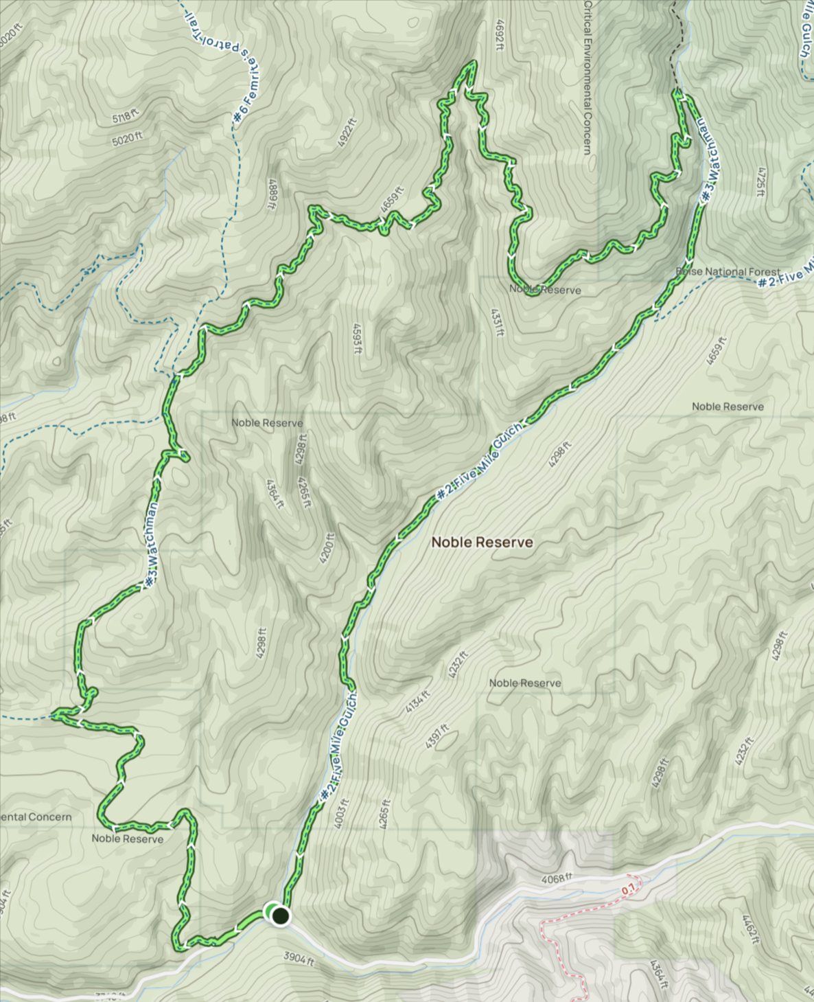

This loop hike in the Boise Foothills has become a new favorite. It has some great views, diverse landscapes, beautiful wildflowers, a variety of songbirds, and a little challenge to keep it interesting. The trailhead is off Shaw Mountain Rd above Fort Boise (43.630626, -116.106205). Shaw Mountain Rd becomes a somewhat narrow dirt road for about the last 1.5-2 miles before you reach the small parking area. Go slow and watch out for other cars, mountain bikers, joggers, and hikers. Seriously, go slow. This is a popular hiking and mountain biking trailhead, so find a parking spot where you can.
Challenges:
Parking can be difficult, depending on when you arrive. The earlier the better.
There are a few stream crossings, but they are easy with stones to step on or bridges in place.
The first 2 miles are mostly a gradual climb with a few plateaus and slight downhill sections. Most of the elevation gain happens here. Take breaks as needed and stay hydrated.
The rest of the trail is pretty level or downhill, but be careful, there are lots of roots and rocks that can trip you up. The views often pull your eyes away from the trail; it’s better to just stop and take in the views.
The last 2 miles are all downhill, but the trail gets pretty sandy, so make sure you are wearing good shoes, preferably boots. It is easy to slide and lose your footing.
Hiker’s Notes:
Trail etiquette dictates that a hiker always makes way for bikes by stepping off the trail so they can pass.
Ticks become prevalent in the tall grass after April. Make sure you protect yourself and your dogs if you bring them along.
Equipment:
Water
Snack
Sunscreen (recommended)
Bug Repellent (recommended)
Hat (recommended)
Good, broken-in hiking boots or shoes
Weather-appropriate clothing
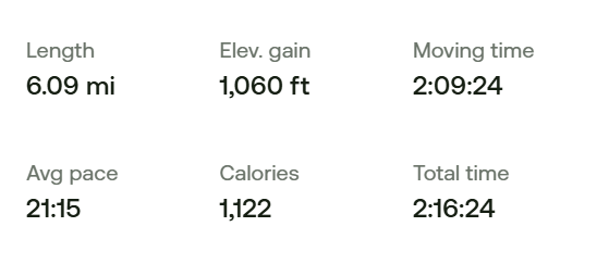
We have hiked this trail before, so this time, to keep it interesting, we tried it in reverse. We figured the prettiest part of the hike was along the creek, so we wanted to hike that last. We weren’t wrong. That was a great way to end the hike, downhill and along water among trees and grasses.
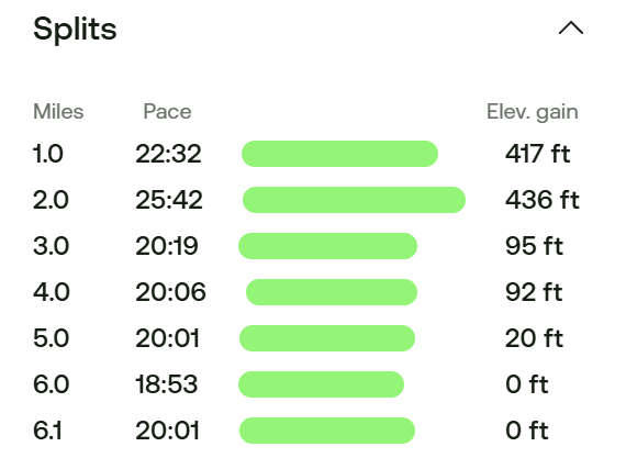
Either way you go, you are looking at about 2 miles of vertical, followed by 2 miles of mostly flat, and ending with 2 miles of downhill. We may have been a little less in shape on this hike than the last time because the elevation gain seemed more intense than we remembered going the other way. Looking at the map, we climbed an additional 200 feet over those two miles. Coming the other direction, that 200 feet comes almost 4 miles into the hike, just before making your descent.
Finding the trailhead isn’t as easy going in reverse. We used AllTrails to track our hike, and I relied on it to get us to our starting point, which is normally the exit point. Once there, the elevation gain starts right away. It was a seemingly long, slow trudge up the hill. Stopping to take in the views was a frequent excuse to try to catch our breath. In those first two miles, you cover 850 feet of elevation. Looking at our splits, we were pretty happy to have done both miles in under 26 minutes.
The first mile is quite sandy. It can be easy to lose your footing if you are wearing inadequate footwear. Mind your footing, but keep an eye on the trail because the mountain bikes can come out of nowhere.
The first three miles of the trail have a single tree along the path for shade, and it is almost four miles to any significant shady section. If you hike the trail in this direction, I recommend starting in the morning. This will be cooler when the shade is scarce, but once the sun is heating up, you’ll have reached the more shady sections of the trail. From the high points of this section, you get gorgeous canyon views and a look down into the Boise Valley.
The last two miles are a gradual downhill saunter. This stretch is wonderful. You hike mostly along Fivemile Creek; the vegetation is plentiful, and a breeze is usually blowing up the canyon. While you don’t get the open landscape views, I find the numerous wildflowers, trees, grasses, creeks, butterflies, and bumblebees more exciting. It is a fantastic section to end on. I should note that this is the section most people start on. It can get a little crowded, especially as you get closer to the trailhead. Just remember your hiker’s etiquette and make way for the people going uphill.
That is the end of this loop. It is an incredible hike. Still a favorite of the Boise Foothills Ridge to Rivers Trail System.
I hope you enjoy our adventure and get the chance to enjoy this hike yourselves.